Adventures while walking about Auburn, Alabama and its environs...
[ABOUT] - [MAP] - [LINKS] - [EMAIL]
Public or Private?
This morning I took a short walk and documented an interesting little lane in Auburn which is not clearly marked as either a public or private road. The following two videos explain:
More evidence that this thoroughfare is, in fact, a public road is this screen shot take from the Lee County public land plat website (I scribbled in the red line to show the route a walked in the videos above):
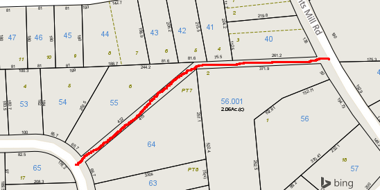
If this map is accurate, then the various private properties in the area clearly end along the edge of this lane. It just seems that this public road has no official name nor any stop signs. It seems to have fallen through the municipal cartography cracks...
Article Topics:
roads_scholar
unpaved_roads
2025 [3]
2024 [5]
2023 [8]
2022 [4]
2021 [9]
2020 [13]
2019 [26]
· DECEMBER [1]
· OCTOBER [2]
· SEPTEMBER [2]
· AUGUST [3]
· JULY [2]
| 14th | More Dirt On Auburn's Roads |
| 7th | Public or Private? |
· JUNE [1]
· MAY [2]
· APRIL [2]
· MARCH [4]
· FEBRUARY [6]
· JANUARY [1]
2018 [1]
2017 [1]
2016 [3]
2015 [1]
Topics
· animals
· auburn_university
· bridges
· camp_hill
· cemeteries
· chewacla_state_park
· churches
· creeks
· foraging
· libraries
· little_texas
· loachapoka
· maps
· milling_about
· notasulga
· puzzle_parties
· roads_scholar
· roxana
· ruins
· saugahatchee_road
· schools
· signposts
· springvilla
· stage_road
· trains
· tuskegee_national_forest
· underground
· unpaved_roads
· weather
Offbeat Auburn website, Copyright © 2015 - 2025, Eric Harshbarger