Adventures while walking about Auburn, Alabama and its environs...
[ABOUT] - [MAP] - [LINKS] - [EMAIL]
Mystery on Chisholm Drive
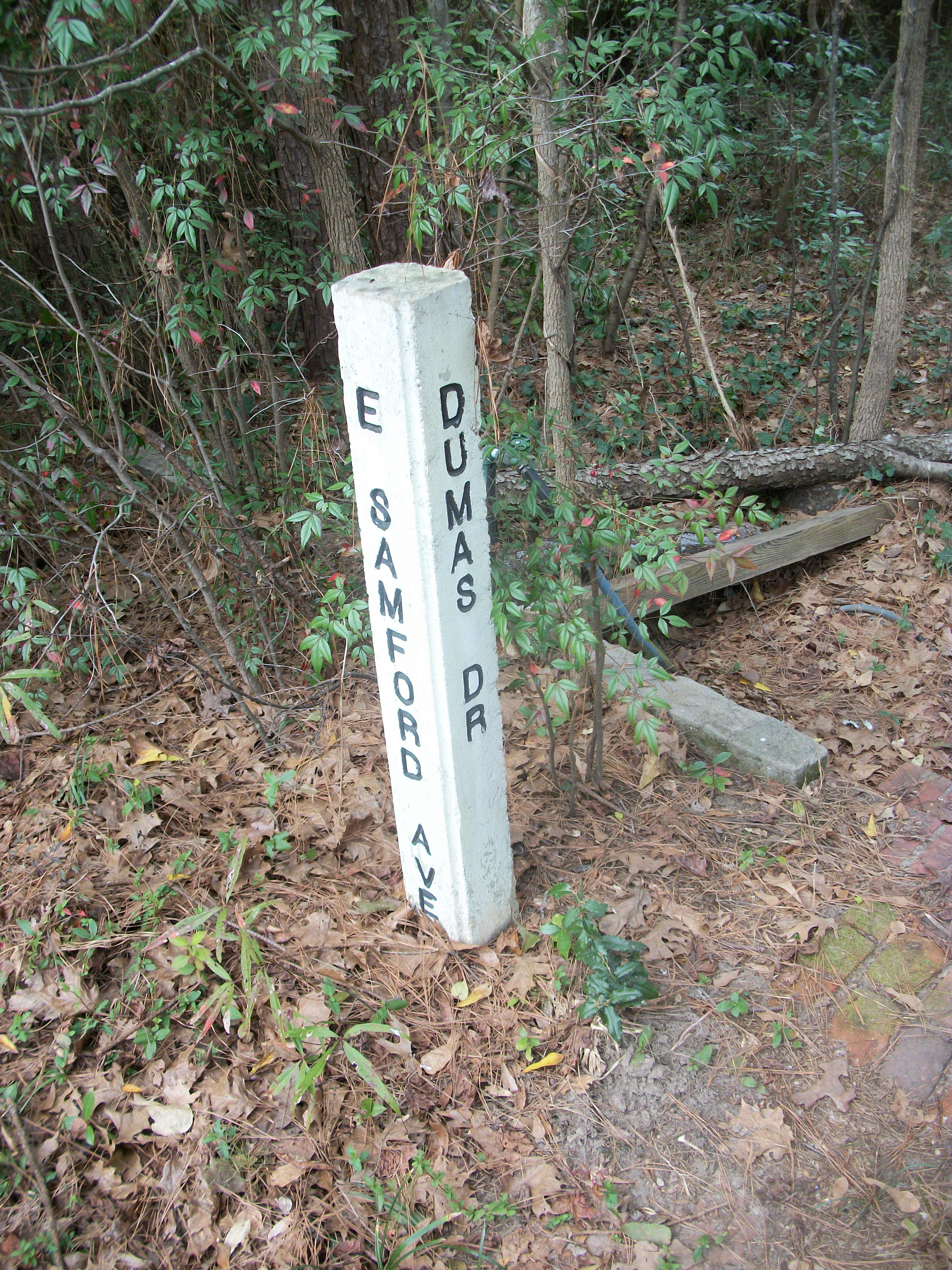
When I was growing up in Auburn, the streets were originally designated by green metal signs affixed to the tops of metal poles at the appropriate street corners. Sometime during the mid-1980s the city replaced all of those signs with concrete posts, like this one:
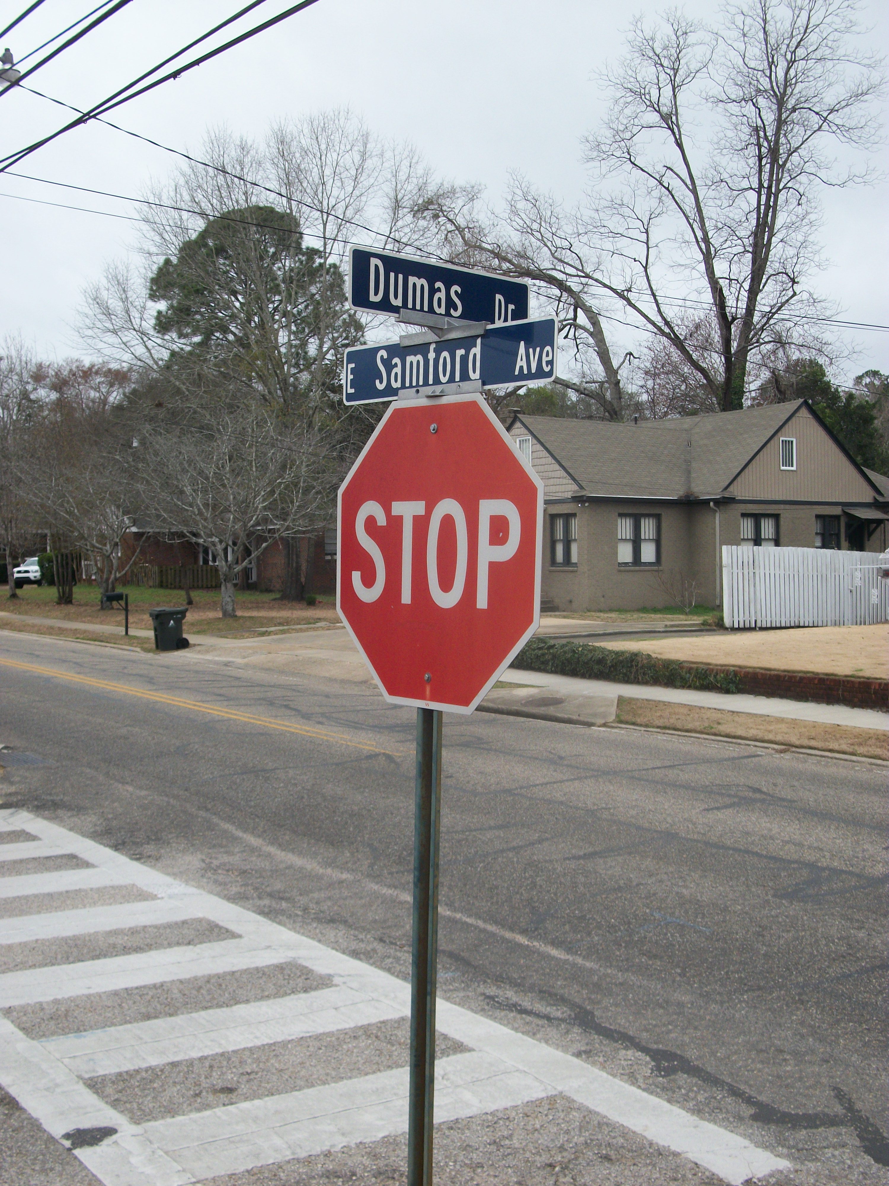
Now, in the past decade, the city has gone back to the metal-sign-atop-pole scheme, but with blue signs instead of green:
As an adult I had had a peculiar memory concerning these road signs. I seemed to recall a concrete sign for a street that did not exist. Back in the 80s, when my family still lived in the Stage Road subdivision, and when the concrete signs were about town, I remembered seeing one of those sign for a "Chisholm Dr". To this day I have a crystal clear mental image of seeing such a signpost at a very particular intersection in my neighborhood.
The Stage Road subdivision comprises six main streets, laid out in a quadrilateral: Stage Road, Cumberland Drive, and Apache (which I lived on), Seminole, Thorpe, and Shawnee Streets. But if you look at at the midpoint of the Shawnee Street span, you'll note that there is a small spur of a road.
I would swear on my life that, at one time, there was a concrete signpost at the corner labeling this as "Chisholm Dr".
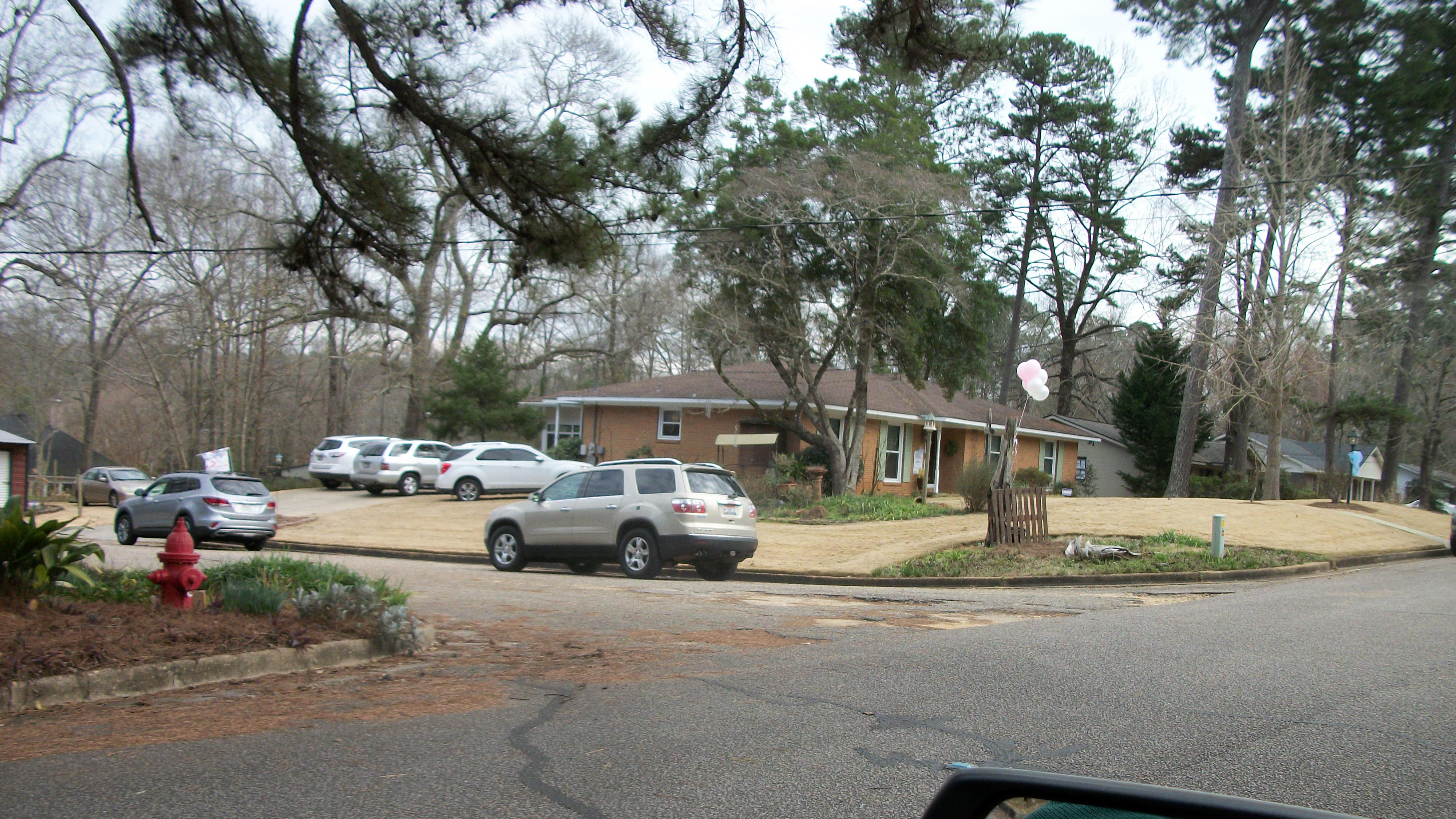
But these days there is no such marker (either concrete post or metal pole). Here is a picture of that intersection today:
So, what was going on? Had I been imagining this for a couple of decades? Had I dreamt the existence of such a signpost? Was that spur of a street ever really named?
This was a small mystery to me for much of my adult life, but I'm happy to report that a couple of years ago I finally got to the bottom of it.
And I hadn't been crazy.
The mystery was solved when I happened to stumble upon an old City of Auburn road map I'd had in a closet. It was a Rand McNally map from 1989 (the last year my family lived in the Stage Road neighborhood). And, lo and behold, clearly marked on the map is a "Chisholm Dr":
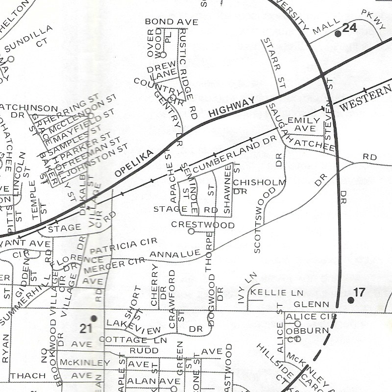
I hadn't made all of this up! But what happened to Chisholm Drive? In the photograph above, it is clearly not designated by a street sign of any type.
I got that answer by speaking with someone at City Hall (a woman in charge of keeping track of Auburn City maps). The woman, Tyler, did some quick research and told me that at one point, yes, that spur of a road was a city street named Chisholm Drive. But, at some point, the city renounced claim on that land and the property was split among the two homeowners on either side of the spur.
Evidently, when the Stage Road subdivision was first built (sometime in the late 60s or early 70s), the developer had plans to expand the neighborhood to the east. So, that spur was paved with the expectation to lengthen it, and it was given a name "Chisholm Drive" (likely named after Chisholm Trail, keeping with the Western/Native American theme of street names).
However, the planned expansion must never have occurred. There is another subdivision adjacent to the east these days, the Burke Place neighborhood, but when it was built (in the mid-to-late 90s) none of its streets hooked up with the existing spur of Chisholm Drive. It was probably around that time that the city thought, "hey, no one actually uses this bit of a road, we don't want to be responsible for maintaining it."
You'll notice a couple more things about the photograph of the intersection above:
- There is no stop/yield sign at the corner, as there are at all intersections of city streets,
- and the asphalt along the spur is in much poorer condition than that of Shawnee Street (which is partially visible). The city has not repaved that spur as recently as they have Shawnee Street.
That land is private property now (this is also discernable from Lee County Public GIS map).
So, mystery solved. At one time there was a Chisholm Drive in Auburn, Alabama.
But no more.
Article Topics:
maps
roads_scholar
signposts
stage_road
2024 [5]
2023 [8]
2022 [4]
2021 [9]
2020 [13]
2019 [26]
· DECEMBER [1]
· OCTOBER [2]
· SEPTEMBER [2]
· AUGUST [3]
· JULY [2]
· JUNE [1]
· MAY [2]
· APRIL [2]
· MARCH [4]
· FEBRUARY [6]
| 17th | Exit 57 |
| 12th | 75 Years Later |
| 10th | Mystery on Chisholm Drive |
| 7th | Map of My Progress |
| 6th | The Dirt Road |
| 3rd | Saugahatchee Creek Bridge |
· JANUARY [1]
2018 [1]
2017 [1]
2016 [3]
2015 [1]
Topics
· animals
· auburn_university
· bridges
· camp_hill
· cemeteries
· chewacla_state_park
· churches
· creeks
· foraging
· libraries
· little_texas
· loachapoka
· maps
· milling_about
· notasulga
· puzzle_parties
· roads_scholar
· roxana
· ruins
· saugahatchee_road
· schools
· signposts
· springvilla
· stage_road
· trains
· tuskegee_national_forest
· unpaved_roads
· weather
Offbeat Auburn website, Copyright © 2015 - 2024, Eric Harshbarger